Gamma Ray Spectrometry
This method measures the concentration and distribution of naturally occurring radioactive elements at the Earth’s surface. Uranium deposits can influence the distribution of these elements through microseepage and other processes. Gamma ray spectrometry can detect these patterns, providing valuable information for uranium exploration.
Magnetic Surveys
These surveys measure variations in the Earth’s magnetic field caused by underlying rock formations. Uranium deposits are often associated with specific geological structures that can be identified through magnetic anomalies. By mapping these anomalies, geophysicists can infer the presence of uranium-bearing formations.
Electromagnetic (EM) Surveys (Including VLF-EM)
EM methods measure the electrical conductivity of subsurface materials. Uranium deposits can be associated with resistive anomalies due to the presence of uranium minerals, or deposited in association of the geological discontinuities which are conductors of electricity. EM surveys can detect these resistivity anomalies, helping to identify potential uranium resources.
Case History1: Inversion Modelling of Athabasca Uranium-Associated Alteration using Matrix™ VLF-EM
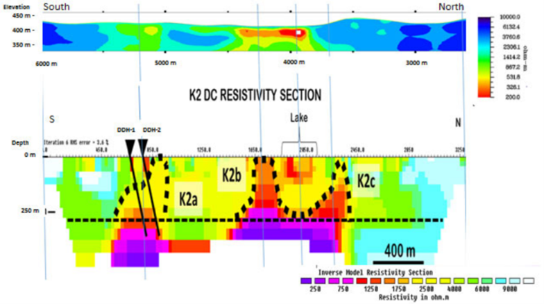
The Athabasca Basin, in Northern Saskatchewan, is host to some of the world’s highest grade uranium mines. With uranium prices starting to rise and exploration interest growing, methods that can add targeting value without requiring excessive budgetary expenditures, can play a key role.
In this example, the geologic model is unconformity style. Here, high grade uranium mineralization located along the unconformity between the basement and overlying sandstones has been remobilized upwards by hydrothermal fluids along steeply dipping faults — creating resistivity breaches (highs) in the sediments which are characterized by uranium and associated alteration.
Putting Matrix™ VLF into Action for Uranium-Associated Alteration
Terraquest recently performed a Matrix™ VLF-EM case study for uranium exploration in the Athabasca Basin. The purpose of the test was to determine if low-cost, shallow airborne VLF-EM survey techniques can be effective in identifying resistivity breaches. The VLF-EM data were inverted and are shown here compared with drill hole information and a DCIP resistivity profile.
As shown in the figure below, the inversion of airborne Matrix™ VLF-EM in upper panel is at same vertical scale as the coincident inverted DCIP resistivity section. The image shows excellent correlation with the upper reaches of the DCIP resistivity breaches.
Case History2: Direct Exploration for Uranium using Max-Gamma™ Airborne Radiometric Surveys
The survey area was prospective for uranium and the targets were over barren rock – meaning that radiometric surveys were optimal for the project.
As this is a uranium target, the approach is a survey focusing on the uranium channel almost solely. However, in this case, the total field data are also illustrative and are compared with vertical derivative magnetics data as well.
Putting a Max-Gamma™ Airborne Radiometric Survey into Action for Uranium
In working on the project, the objective was to completely map the area – extracting high quality data following appliable over flights, test flights, calibrations, and actual surveying. The data are shown below with total count results, uranium channel results and vertical magnetic derivative.
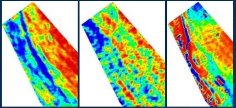
The specific results are that:
- Total count data show the structures in the area, running predominantly north-south with a zone of alteration along the right of the image.
- Vertical derivative data (right) show the persistence of interbedded magnetic units to the west of the image with some alteration (orange) as well.
- The middle map is the key map for uranium exploration – it shows directly where the uranium is in the context of nearby structures illustrated by the total count and vertical magnetic derivative results.
Case History3: Inversion Modelling of Athabasca Uranium-Associated Alteration using Matrix™ VLF-EM
The Athabasca Basin, in Northern Saskatchewan, is host to some of the world’s highest grade uranium mines. With uranium prices starting to rise and exploration interest growing, methods that can add targeting value without requiring excessive budgetary expenditures, can play a key role.
In this example, the geologic model is unconformity style. Here, high grade uranium mineralization located along the unconformity between the basement and overlying sandstones has been remobilized upwards by hydrothermal fluids along steeply dipping faults — creating resistivity breaches (highs) in the sediments which are characterized by uranium and associated alteration.
Putting Matrix™ VLF into Action for Uranium-Associated Alteration
Terraquest recently performed a Matrix™ VLF-EM case study for uranium exploration in the Athabasca Basin. The purpose of the test was to determine if low-cost, shallow airborne VLF-EM survey techniques can be effective in identifying resistivity breaches. The VLF-EM data were inverted and are shown here compared with drill hole information and a DCIP resistivity profile.
As shown in the figure below, the inversion of airborne Matrix™ VLF-EM in upper panel is at same vertical scale as the coincident inverted DCIP resistivity section. The image shows excellent correlation with the upper reaches of the DCIP resistivity breaches.