Magnetic Surveys
These detect variations in the Earth’s magnetic field caused by the presence of magnetic minerals, which can indicate the presence of base metals.
Electromagnetic (EM) Surveys (Including VLF-EM)
These measure the ground’s conductivity to identify conductive minerals or geological structures, such as those containing base metals.
Gravity Surveys
These measure variations in the Earth’s gravitational field to identify denser mineral deposits.
Radiometric Surveys
These measure natural radioactivity to identify certain types of mineral deposits.
Case History 1: Lead Zinc Targeting using EmPower™ Helicopter Time Domain Electromagnetics
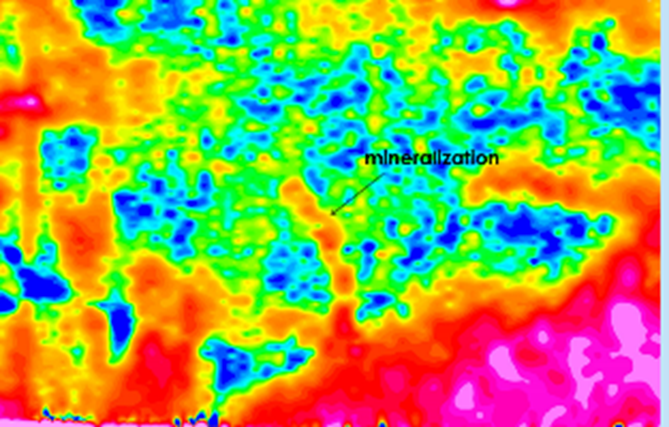
In this example in volcanics, there is known lead (pb) and zinc (zn) mineralization located below 95 m of weakly conductive overburden. The mineralization has a similar (low) conductance and therefore, corresponding low-amplitude profiles.
The object of the survey was to map the extent of the mineralization (unknown at the time) and identify the strike and dip directions as well as the exact drill targeting locations. Previously this zone was only seen with the CSAMT method.
Terraquest’s EmPower™ helicopter time domain EM survey was the source of data shown in this case history. A loop recorded time domain electromagnetic data at a range of sampling times, up to 600 microseconds. The background resistance in the area is relatively uniform at 200 ohm-m.
Putting an EmPower™ HTEM Survey into Action for Base Metals
In working on the project, Terraquest’s survey design personnel were led by several factors including the effectiveness of helicopter time domain electromagnetics for investigating deep and shallow targets mineralized with sulphides.
We can see that drill targets are already emerging. In the image below, we see time constants for sulphide-bearing rocks in the area with high times indicating persistent sulphide-rich mineralization.
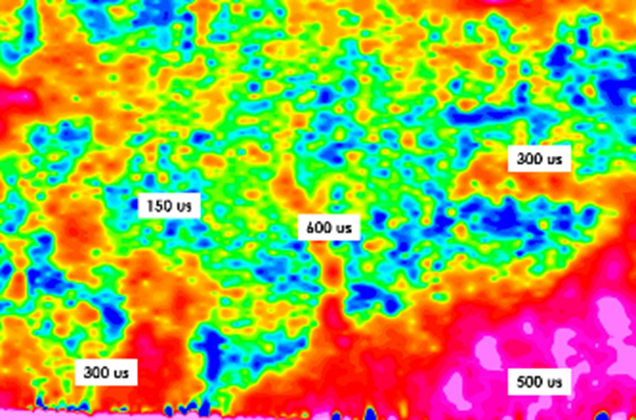
The specific results are that:
- Drill targets are located correctly over the 600 microsecond body.
Case History2: Mapping Ultramafic Base Metal Targets using Integrated Magnetics and Gravity
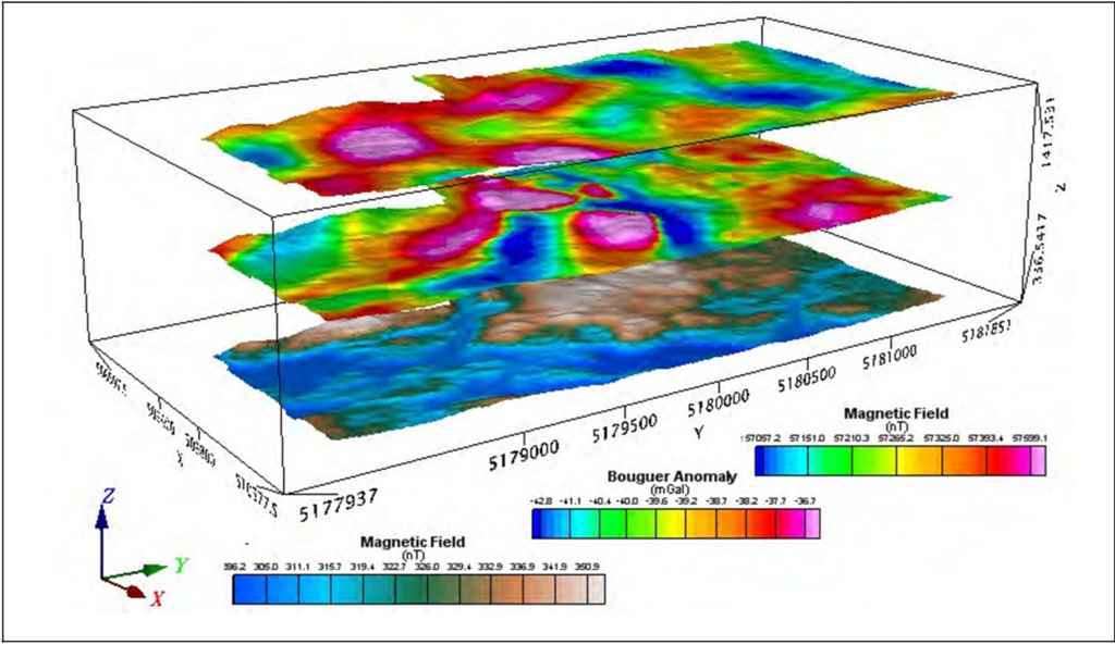
The survey area was prospective for base metals and both Resolution™ airborne magnetic surveys and Equilibrium™ airborne gravity surveys were employed.
Putting Resolution™ Magnetics and Equilibrium™ Gravity Surveys into Action for Base Metals
In working on the project, the objective was to obtain high resolution magnetics and gravity data that could be used to detect the presence of metallic units in an ultramafic environment. In addition, Lidar data was acquired for precise mapping of the ground surface. The survey image is shown below.
The specific results are that:
- The magnetics data showed three magnetic highs that are interpreted to be ultramafic rocks
- The integrated gravity data illustrated that the gravity data was coincident with the magnetics to the west of the area and that there was a unique anomaly in the centre of the map.
- The area in the centre of the map (gravity data) flanking a magnetic high is indicated as the prospective zone in this environment.