Magnetic Surveys: These surveys measure variations in the Earth’s magnetic field caused by underlying rock formations. Gold deposits are often associated with mineralized zones containing magnetic minerals like pyrrhotite and magnetite. By mapping these magnetic anomalies, geophysicists can identify potential gold-bearing structures.
- Gravity Surveys: Gravity surveys assess variations in gravitational pull caused by differences in subsurface density. Gold deposits can be associated with denser rock formations due to the presence of sulfide minerals. Gravity surveys help delineate such anomalies and infer the potential presence of gold-bearing structures.
- Electromagnetic (EM) Surveys (Including VLF-EM): EM methods measure the electrical conductivity of subsurface materials. Gold deposits are often linked with sulfide minerals or specific alterations, which can conduct electricity differently from surrounding rocks. EM surveys can detect conductive anomalies that may indicate the presence of mineralized zones.
Case History1: Inversion Modelling of Gold-Vein Mineralization using Matrix™ VLF-EM
Background
The Lingman Lake gold property consists of four free hold patented claims and 762 single cell staked claims. Total land package amounts to 15,372.3 hectares. 275.5 hectares of the property total include 14 mineral rights patents.
The property hosts an historic estimate of 234,684 oz of gold* (1,063,904 tonnes grading 6.86 g/t with 2.73 gpt cut-off) and includes what has historically been referred to as the Lingman Lake Gold Mine, an underground substructure consisting of a 126.5-meter shaft, and 3-levels at 46-meters, 84-meters and 122-meters depths.
Putting Matrix VLF into Action
In 2018, Terraquest Ltd. was contracted to perform a Matrix™ VLF survey over the property by Signature Resources.
FEATURES AND HIGH PRIORITY TARGETS
FOR IMMEDIATE RELEASE
June 11, 2018Download
This news release describes their findings from the survey which introduced a new element into VLF-EM processing, namely Inversions, which provide cost-effective near surface mapping for gold targets.
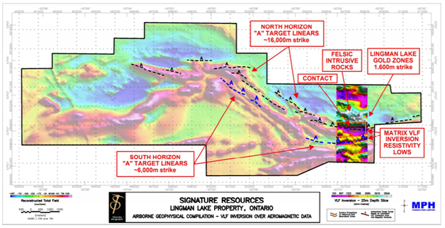
The results showed:
- enhanced resolution of the controlling contact between felsic intrusives and mafic metavolcanics.
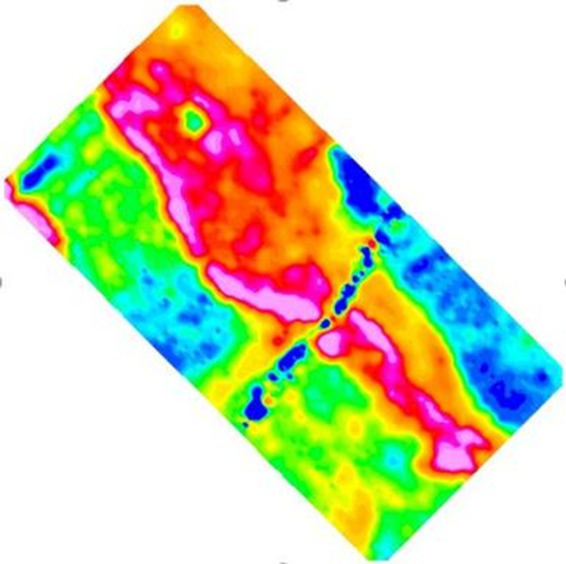
- a distinctive, broad resistivity low that correlates with a known mineralized, gold vein system and alteration (Lingman Gold Deposit) and numerous other occurrences along a 22 kilometre strike, even where thin surficial conductivity is present as shown by the total field VLF data.
- that the depth slices are unimpaired at depth by known surficial conductivity, as shown in the 40 metre resistivity depth slice presented in the press release.
Case History2: Mapping Gold Alteration using EmPower™ Helicopter Time Domain Electromagnetics
In this example in volcanics, there is an active gold mine in the area making the region prospective for associated offshoots of mineralization.
The object of the survey was to map the extent of the volcanics, but more importantly, show their relationship to any detected alteration imaged using Terraquest’s EmPower™ Helicopter Time Domain Electromagnetics system.
Putting an EmPower™ EM Survey into Action for Gold Alteration near Volcanics
In working on the project, survey design personnel were led by several factors including the effectiveness of helicopter time domain electromagnetics for mapping volcanics based on their contained sulphides as well as alteration containing re-mobilized sulphides.
The specific results are that:
- The volcanic unit contains an active gold mine to the northwest that is moderately conductive.
- The volcanic unit also contains conductive alteration zones (hydrothermal fractures that have altered the volcanics) that are thought to hold the gold mineralization.
- The project goal was achieved in mapping the outline of the volcanic unit and in identifying the alteration trends within.
- The area has several powerlines, highways, and houses – powerline is linear cross-cutting feature in blue.