Electromagnetic (EM) Surveys
EM methods measure the electrical conductivity of subsurface materials. Hydrocarbon deposits can be associated with resistive anomalies due to the presence of hydrocarbons, which are poor conductors of electricity. EM surveys can detect these resistive anomalies, helping to identify potential hydrocarbon reservoirs.
Magnetic Surveys
These surveys measure variations in the Earth’s magnetic field caused by underlying rock formations. Hydrocarbon deposits are often associated with specific geological structures that can be identified through magnetic anomalies. By mapping these anomalies, geophysicists can infer the presence of hydrocarbon-bearing formations.
Gravity Surveys
Gravity surveys assess variations in gravitational pull caused by differences in subsurface density. Hydrocarbon deposits can be associated with less dense rock formations due to the presence of hydrocarbons. Gravity surveys help delineate such anomalies and infer the potential presence of hydrocarbon reservoirs.
Gamma Ray Spectrometry
This method measures the concentration and distribution of naturally occurring radioactive elements at the Earth’s surface. Hydrocarbon deposits can influence the distribution of these elements through microseepage and other processes. Gamma ray spectrometry can detect these patterns, providing valuable information for hydrocarbon exploration.
Case History: Mapping Oil Basins Using Terraquest’s Equilibrium™ Airborne Gravity Survey
The Ngoki region is one of the world’s last frontiers for oil exploration. The governments of both the Republic of Congo and neighbouring Democratic Republic of Congo have signed various exploration deals with oil majors here. But so far its oil reserves have remained largely unknown and unexplored, largely due, in part, to its extreme remoteness and other factors.
Terraquest was able to overcome these limitations in conducting an extensive airborne gravity survey over the area. These results show potential oil formations that must be verified through seismic surveys and exploratory wells in future.
Putting an Equilibrium Gravity Survey into Action for Oil Hosting Basement Rocks
In working on the project, the objective was to obtain high resolution gravity data that could be used to detect the presence of potentially oil-bearing sedimentary units. The survey image is shown below.
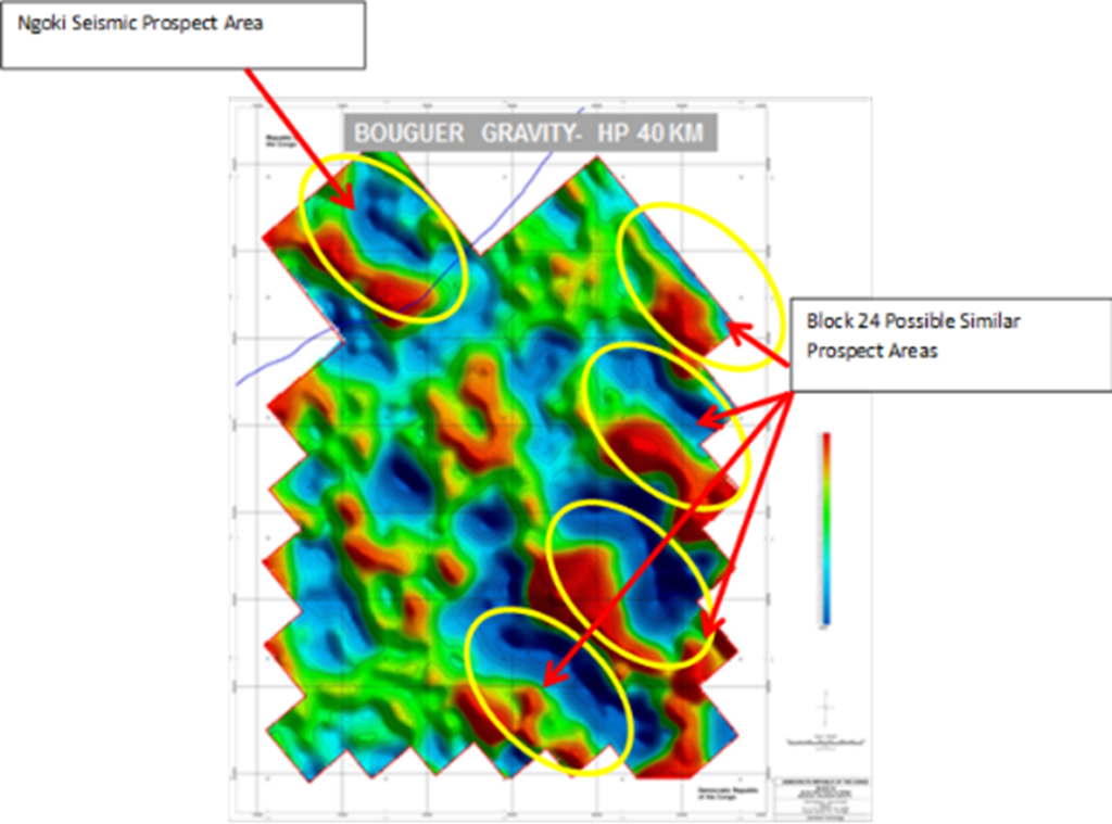
Figure 1: A series of prospective sedimentary basins (gravity lows in blue) are indicated here, lying here equally spaced with intermittently placed denser rocks (red).
The specific results are that:
- The survey confirmed the signature of sedimentary basins here in the vicinity of the Ngoki Seismic Prospect Area.
- Four additional sedimentary basins were postulated.
- The data were very high resolution — reflecting the quality of the airborne survey.
- The data were noise free reflecting the quality of the instrumentation used for data acquisition.